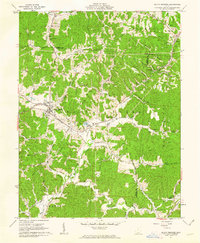
1961 Map of South Webster
USGS Topo · Published 1962About this map
Clay mining and iron industry history define this portion of Scioto County, as evidenced by the numerous Claypit labels and legacy settlements like Firebrick and Olive Furnace. The area's complex topography is organized by the Baltimore and Ohio Railroad and the Detroit Toledo and Ironton Railroad, which converge near Bloom Junction. These rail lines follow the winding valleys carved by Furnace Creek and Hales Creek, linking small communities such as Pinkerman and Eifort. The cultural landscape is heavily shaped by local genealogy, with numerous family and community burial grounds including Jackson Furnace Cem, Monroe Cem, and Bloom Furnace Cem. Much of the eastern terrain falls within the Wayne National Forest, where features like the Simmering Lookout Tower overlook the ridge-and-hollow system of Diamond Hollow and Slab Hollow.
Find a feature on this map
66 named features on this map. Tap any name to fly to it.
Don’t see what you’re looking for? This feature index may not catch every label — zoom into the map to look around manually.
Map Details
Editions of this 1961 South Webster Map
2 editions found
Other maps of this area

1898 · Ironton
USGS Topo · 1:62,500

1900 · Ironton
USGS Topo · 1:62,500

1911 · Sciotoville
USGS Topo · 1:62,500

1912 · Oak Hill
USGS Topo · 1:62,500

1913 · Sciotoville
USGS Topo · 1:62,500

1926 · Greenup
USGS Topo · 1:48,000

1930 · Greenup
USGS Topo · 1:62,500

1957 · Huntington
USGS Topo · 1:250,000

1960 · Huntington
USGS Topo · 1:250,000
1961 · Petersburg
USGS Topo · 1:24,000