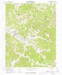
1961 Map of South Webster
USGS Topo · Published 1977About this map
The industrial and extractive history of Southern Ohio is clearly legible in this 1961 survey, where the intersecting tracks of the Baltimore and Ohio Railroad, the Toledo and Ohio Central Railroad, and the Detroit Toledo and Ironton Railroad converge near South Webster. This rail-heavy landscape served as a conduit for the region's natural resources, particularly its fireclay and coal. Numerous Claypits and Strip Mines are scattered across the terrain, notably near Firebrick and Eifort, marking the footprint of the brick-making and mining operations that once drove the local economy.
Find a feature on this map
70 named features on this map. Tap any name to fly to it.
Don’t see what you’re looking for? This feature index may not catch every label — zoom into the map to look around manually.
Map Details
Editions of this 1961 South Webster Map
2 editions found
Other maps of this area

1898 · Ironton
USGS Topo · 1:62,500

1900 · Ironton
USGS Topo · 1:62,500

1911 · Sciotoville
USGS Topo · 1:62,500

1912 · Oak Hill
USGS Topo · 1:62,500

1913 · Sciotoville
USGS Topo · 1:62,500

1926 · Greenup
USGS Topo · 1:48,000

1930 · Greenup
USGS Topo · 1:62,500

1957 · Huntington
USGS Topo · 1:250,000

1960 · Huntington
USGS Topo · 1:250,000
1961 · Petersburg
USGS Topo · 1:24,000