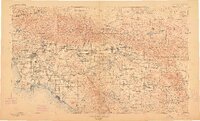
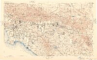
1901 Map of Southern California Sheet No. 1
USGS Topo · Published 1912About this map
The sprawling Basin of Southern California is documented here just after the turn of the century, showing a landscape defined by its coastal settlements and the high peaks of the San Gabriel Mountains and San Bernardino Mountains. From the developed core of Los Angeles and Pasadena, the map traces the early expansion of the citrus belt through Pomona, Ontario, and Redlands. The complex hydrology of the region is evident in the courses of the Santa Ana River and San Gabriel River, while the high country features landmarks like Mt. San Antonio and San Gorgonio Mt.. To the south, the terrain descends through the Santa Ana Mountains into the Lake Elsinore basin. This era marks the height of the steam rail network, with the Southern Pacific R. R. and the Atchison Topeka and Santa Fe R. R. anchoring the movement of people and agriculture between the inland valleys and the Pacific Ocean.
Find a feature on this map
62 named features on this map. Tap any name to fly to it.
Don’t see what you’re looking for? This feature index may not catch every label — zoom into the map to look around manually.
Map Details
Editions of this 1901 Southern California Sheet No. 1 Map
6 editions found

Other maps of this area

1894 · Los Angeles
USGS Topo · 1:62,500

1894 · Pomona
USGS Topo · 1:62,500

1896 · Santa Ana
USGS Topo · 1:62,500

1896 · Pasadena
USGS Topo · 1:62,500

1896 · Anaheim
USGS Topo · 1:62,500

1896 · Redondo
USGS Topo · 1:62,500

1896 · San Bernardino
USGS Topo · 1:62,500

1896 · Las Bolsas
USGS Topo · 1:62,500

1896 · Santa Monica
USGS Topo · 1:62,500

1896 · San Pedro
USGS Topo · 1:62,500