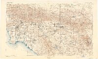
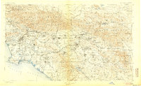
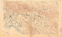
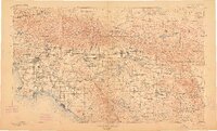
1901 Map of Southern California Sheet No. 1
USGS Topo · Published 1921About this map
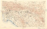
Los Angeles and its emerging coastal neighbors define the western edge of this comprehensive Southern California turn-of-the-century survey. The landscape transitions from the shores of San Pedro Bay and the salt-air reaches of Santa Monica through the dense network of Spanish land grants toward the inland empires of San Bernardino and Riverside. Transportation is dominated by the competing corridors of the Santa Fe R. R. and Southern Pacific R. R., which navigated the formidable geography of the San Gorgonio Pass and the Cajon Creek drainage.
Find a feature on this map
146 named features on this map. Tap any name to fly to it.
Don’t see what you’re looking for? This feature index may not catch every label — zoom into the map to look around manually.
Map Details
Editions of this 1901 Southern California Sheet No. 1 Map
6 editions found

Other maps of this area

1894 · Los Angeles
USGS Topo · 1:62,500

1894 · Pomona
USGS Topo · 1:62,500

1896 · Santa Ana
USGS Topo · 1:62,500

1896 · Pasadena
USGS Topo · 1:62,500

1896 · Anaheim
USGS Topo · 1:62,500

1896 · Redondo
USGS Topo · 1:62,500

1896 · San Bernardino
USGS Topo · 1:62,500

1896 · Las Bolsas
USGS Topo · 1:62,500

1896 · Santa Monica
USGS Topo · 1:62,500

1896 · San Pedro
USGS Topo · 1:62,500