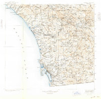
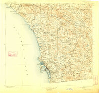
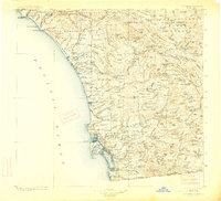
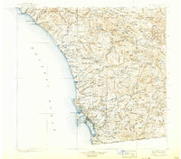
1904 Map of Southern California Sheet No. 2
USGS Topo · Published 1948About this map
San Diego and its surrounding coastal settlements are depicted here as they appeared at the turn of the century, prior to the massive urban expansion of the later 1900s. The coastline is dominated by the Atchison Topeka and Santa Fe RR, which connects coastal hubs like Oceanside, Carlsbad, and Encinitas to the growing port at San Diego Bay. Inland, the map reveals a landscape defined by ranching and early irrigation, with prominent water features like the Sweetwater Reservoir and the Lower Otay Reservoir serving the arid valleys. A notable concentration of sovereign lands, including the Pala Indian Res. and Santa Ysabel Indian Res., marks the rugged interior transition toward the Cleveland National Forest. This survey captures the region's early transition from a series of isolated missions and ranchos like San Luis Rey and San Juan Capistrano into a networked rail-and-maritime economy.
Find a feature on this map
207 named features on this map. Tap any name to fly to it.
Don’t see what you’re looking for? This feature index may not catch every label — zoom into the map to look around manually.
Map Details
Editions of this 1904 Southern California Sheet No. 2 Map
5 editions found

Other maps of this area

1893 · El Cajon
USGS Topo · 1:62,500

1893 · Oceanside
USGS Topo · 1:62,500

1893 · Escondido
USGS Topo · 1:62,500

1896 · Santa Ana
USGS Topo · 1:62,500

1898 · Oceanside
USGS Topo · 1:62,500

1901 · Southern California Sheet No. 1
USGS Topo · 1:250,000

1901 · Elcajon
USGS Topo · 1:62,500

1901 · Santa Ana
USGS Topo · 1:62,500

1901 · San Jacinto
USGS Topo · 1:125,000

1901 · Elsinore
USGS Topo · 1:125,000