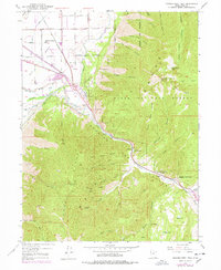
1949 Map of Spanish Fork Peak
USGS Topo · Published 1978About this map
Spanish Fork flows through a landscape defined by sharp elevation shifts and early industrial footprints at the edge of the Uinta National Forest. The western lowlands are marked by a complex irrigation network, including the Salem Canal, South Field Canal, and Salem High Line Canal, supporting the agricultural benchlands near Mapleton Siding. Industrial activity is concentrated along the Denver and Rio Grande Western Railway, where Moark Junction serves as a critical transit point near a Powder Plant and a large Gaging Station. To the east, the terrain rises dramatically toward the summits of Spanish Fork Pk and Loafer Mountain. Local history and folklore are embedded in the slopes, notably at the Dream Mine and the Old Spanish Mine, while high-altitude features like Maple Canyon Lake and Shurtz Lake occupy the drainages of the Wasatch Range.
Find a feature on this map
74 named features on this map. Tap any name to fly to it.
Don’t see what you’re looking for? This feature index may not catch every label — zoom into the map to look around manually.
Map Details
Editions of this 1949 Spanish Fork Peak Map
4 editions found
Other maps of this area

1885 · Salt Lake
USGS Topo · 1:250,000

1885 · Manti
USGS Topo · 1:250,000

1895 · Manti
USGS Topo · 1:250,000

1907 · Strawberry Valley
USGS Topo · 1:125,000

1909 · Strawberry Valley
USGS Topo · 1:125,000

1948 · Spanish Fork
USGS Topo · 1:24,000

1948 · Springville
USGS Topo · 1:24,000

1948 · Provo
USGS Topo · 1:24,000

1949 · Provo
USGS Topo · 1:62,500

1949 · Spanish Fork Peak
USGS Topo · 1:24,000