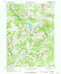
1968 Map of Spartansburg
USGS Topo · Published 1971About this map
Spartansburg serves as the central hub of this 1960s landscape, positioned near the shores of Clear Lake and Patrick Run. The terrain is defined by a series of agricultural and forestry pockets, including the State Game Lands No 144 and the prominent Eastman Hill. The transportation network of the era is anchored by the Penn Central railroad, which threads through the valley near the South Branch French Cr and Oil Creek.
Find a feature on this map
32 named features on this map. Tap any name to fly to it.
Don’t see what you’re looking for? This feature index may not catch every label — zoom into the map to look around manually.
Map Details
Editions of this 1968 Spartansburg Map
4 editions found
Other maps of this area

1927 · Townville
USGS Topo · 1:48,000

1927 · Titusville
USGS Topo · 1:62,500

1929 · Corry
USGS Topo · 1:48,000

1929 · Union City
USGS Topo · 1:62,500

1932 · Corry
USGS Topo · 1:62,500

1932 · Townville
USGS Topo · 1:62,500

1932 · Union City
USGS Topo · 1:62,500

1933 · Titusville
USGS Topo · 1:62,500

1945 · Townville
USGS Topo · 1:62,500

1957 · Warren
USGS Topo · 1:250,000