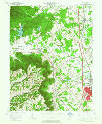
1963 Map of Speed
USGS Topo · Published 1974About this map
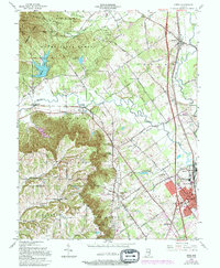
The rugged Knobs dominate the western landscape of this southern Indiana region, providing a sharp contrast to the developing valleys of Silver Creek and the Muddy Fork. In the early 1960s, the area shows a clear transition from the managed timberlands of Monroe State Forest and Clark State Forest to the industrial and suburban growth centered around Sellersburg. Significant infrastructure of the era is evident, including the newly formed Deam Lake and the industrial activity at Speed, where the Pennsylvania railroad and the Monon lines converge. For genealogists, the map preserves the locations of several historic burial grounds, such as Bowery Cem, Miller Cem, and Hickory Grove Cem, alongside rural landmarks like Atkins Chapel and the small settlement of Bennettsville.
Find a feature on this map
58 named features on this map. Tap any name to fly to it.
Don’t see what you’re looking for? This feature index may not catch every label — zoom into the map to look around manually.
Map Details
Editions of this 1963 Speed Map
5 editions found
Other maps of this area

1905 · Prospect
USGS Topo · 1:62,500

1912 · Prospect
USGS Topo · 1:62,500

1937 · Jeffersonville
USGS Topo · 1:24,000

1937 · Charlestown
USGS Topo · 1:24,000

1938 · Speed
USGS Topo · 1:24,000

1939 · New Albany
USGS Topo · 1:24,000

1939 · Georgetown
USGS Topo · 1:24,000

1941 · Borden
USGS Topo · 1:24,000

1946 · Jeffersonville
USGS Topo · 1:24,000

1946 · New Albany
USGS Topo · 1:24,000