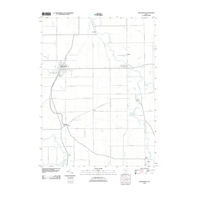
2010 Map of Spencerville
USGS Topo · Published 2010About this map
The Auglaize River and Saint Marys River define the agricultural landscape of this western Ohio region, where historical burial grounds and small settlements mark the landscape. Spencerville serves as the primary hub, containing the Spencerville Post Office and Saint Patricks Cemetery, while the village of Kossuth sits further south along the bend of the river. The area is notable for its high density of family and community burial sites, including the Hartford Cemetery, Jacob Baker Cemetery, and Pratt Cemetery, which offer valuable coordinates for genealogical research in Allen County.
Find a feature on this map
66 named features on this map. Tap any name to fly to it.
Don’t see what you’re looking for? This feature index may not catch every label — zoom into the map to look around manually.
Map Details
Editions of this 2010 Spencerville Map
This is the sole edition of this map. No revisions or reprints were ever made.
Other maps of this area

1906 · Lima
USGS Topo · 1:62,500

1906 · Columbus Grove
USGS Topo · 1:62,500

1908 · Columbus Grove
USGS Topo · 1:62,500

1911 · Spencerville
USGS Topo · 1:62,500

1911 · Delphos
USGS Topo · 1:62,500

1944 · Delphos
USGS Topo · 1:62,500

1944 · Spencerville
USGS Topo · 1:62,500

1953 · Muncie
USGS Topo · 1:250,000

1956 · Muncie
USGS Topo · 1:250,000
1960 · Delphos
USGS Topo · 1:24,000