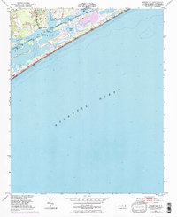
1952 Map of Spicer Bay
USGS Topo · Published 1973About this map
The Intracoastal Waterway winds through a complex network of barrier islands and shallow sounds in this coastal Onslow County area. The mapping, based on 1950s surveys with 1970s revisions, highlights the intricate shorelines of Stump Sound and Everett Bay. Near the small settlement of Thomas Landing, the landscape is defined by tidal marsh and the narrow channels that separate the mainland from Ashe Island and Permuda Island. Marine navigation is a primary focus of the work, indicated by numerous light and daybeacon markers along the waterway, as well as several coastal towers such as Tower Seven and Tower Eight situated near the surf line. Small inlets like Spicer Bay and Rogers Bay illustrate the coastal geography before the heavy development of later decades, offering a clear view of the natural drainage of Turkey Cr and King Cr into the sounds.
Find a feature on this map
17 named features on this map. Tap any name to fly to it.
Don’t see what you’re looking for? This feature index may not catch every label — zoom into the map to look around manually.
Map Details
Editions of this 1952 Spicer Bay Map
3 editions found
Other maps of this area

1942 · Spicer Bay
USGS Topo · 1:62,500

1942 · Topsail
USGS Topo · 1:62,500

1948 · Maple Hill
USGS Topo · 1:62,500

1948 · Topsail
USGS Topo · 1:62,500

1948 · New River
USGS Topo · 1:62,500

1952 · Spicer Bay
USGS Topo · 1:24,000

1952 · New River Inlet
USGS Topo · 1:24,000

1952 · Sneads Ferry
USGS Topo · 1:24,000

1953 · Beaufort
USGS Topo · 1:250,000

1954 · Beaufort
USGS Topo · 1:250,000
Featured Places
- Holly Ridge, NC
- North Topsail Beach, NC
- Thomas Landing, NC
- Ocean City Beach, North Topsail Beach
- Onslow County, NC