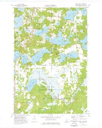
1973 Map of Spirit Lake
USGS Topo · Published 1976About this map
Spirit Lake and Ripple Lake anchor this complex landscape of interconnected glacial basins and wetlands in central Aitkin County. The 1970s terrain is characterized by a high density of named water bodies, including Hanging Kettle Lake, Lone Lake, and Mallard Lake, reflecting the region's post-glacial topography. Human presence is concentrated around small settlements like Bennettville and Hazelton, and through cultural landmarks such as Maria Chapel and the local Townhall. Much of the southern portion of the map is dedicated to conservation and forestry, featuring the Ripple River State Wildlife Management Area and parts of the Wealthwood State Forest. The intricate network of Ripple River channels and marshlands suggests a landscape that has historically dictated transportation and land use, with features like Ditch Bank Road and various Gravel Pits indicating local infrastructure development during the era.
Find a feature on this map
52 named features on this map. Tap any name to fly to it.
Don’t see what you’re looking for? This feature index may not catch every label — zoom into the map to look around manually.
Map Details
Editions of this 1973 Spirit Lake Map
This is the sole edition of this map. No revisions or reprints were ever made.
Other maps of this area

1912 · Deerwood
USGS Topo · 1:62,500

1913 · Cuyuna
USGS Topo · 1:62,500

1914 · Deerwood
USGS Topo · 1:62,500

1914 · Aitkin
USGS Topo · 1:62,500

1915 · Aitkin
USGS Topo · 1:62,500

1915 · Cuyuna
USGS Topo · 1:62,500

1916 · Wealthwood
USGS Topo · 1:62,500

1953 · Duluth
USGS Topo · 1:250,000

1958 · Duluth
USGS Topo · 1:250,000

1973 · Iron Hub
USGS Topo · 1:24,000