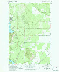
1961 Map of Spirit Lake East
USGS Topo · Published 1986About this map
Spirit Lake serves as the primary hub of this 1960s landscape, positioned along the shores where the Kaniksu National Forest and Coeur d'Alene National Forest converge. The town site shows a structured grid including Madison St and Maine St, with the Greenwood Cem situated on the eastern outskirts. This era was defined by a dense network of industrial transit, as three major railroads—the Chicago Milwaukee St Paul and Pacific, Spokane International, and Great Northern—cut through the timbered terrain and open spaces like Eightmile Prairie. To the south, the shoreline of Twin Lakes is dotted with recreational or residential landings such as Excelsior Beach and Echo Beach, while Harts Island sits just offshore. The topography is dominated by Round Mountain, rising sharply above the valley floor where Ramsey Road and various jeep trails provide access to the interior.
Find a feature on this map
26 named features on this map. Tap any name to fly to it.
Don’t see what you’re looking for? This feature index may not catch every label — zoom into the map to look around manually.
Map Details
Editions of this 1961 Spirit Lake East Map
3 editions found

Other maps of this area

1901 · Sandpoint
USGS Topo · 1:125,000

1903 · Rathdrum
USGS Topo · 1:125,000

1911 · Priest Lake
USGS Topo · 1:250,000

1911 · Sandpoint
USGS Topo · 1:125,000

1913 · Priest Lake
USGS Topo · 1:250,000

1955 · Spokane
USGS Topo · 1:250,000

1958 · Spokane
USGS Topo · 1:250,000

1958 · Sandpoint
USGS Topo · 1:250,000

1961 · Hayden
USGS Topo · 1:24,000

1961 · Rathdrum
USGS Topo · 1:24,000