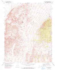
1970 Map of Split Mountain
USGS Topo · Published 1990About this map
Split Mountain dominates the center of this 1970 survey, standing as a prominent landmark between the high elevations of Clayton Ridge to the west and the Montezuma Range to the east. The landscape is defined by the steep, eroded drainages of Nevada Canyon and Jackson Wash, which carve through the high desert terrain of Esmeralda County. Evidence of human activity and industry is scattered across these slopes, including a Mine and various Ruins that point to the region's mineral interests.
Find a feature on this map
12 named features on this map. Tap any name to fly to it.
Don’t see what you’re looking for? This feature index may not catch every label — zoom into the map to look around manually.
Map Details
Editions of this 1970 Split Mountain Map
3 editions found
Other maps of this area

1898 · Silver Peak
USGS Topo · 1:125,000

1900 · Silver Peak
USGS Topo · 1:125,000

1908 · Lida
USGS Topo · 1:250,000

1913 · Lida
USGS Topo · 1:250,000

1945 · Goldfield
USGS Topo · 1:125,000

1954 · Goldfield
USGS Topo · 1:250,000

1955 · Goldfield
USGS Topo · 1:250,000

1958 · Goldfield
USGS Topo · 1:250,000

1962 · Goldfield
USGS Topo · 1:250,000

1963 · Silver Peak
USGS Topo · 1:62,500