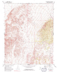
1970 Map of Split Mountain
USGS Topo · Published 1992About this map
Clayton Ridge and the Montezuma Range dominate this high-desert landscape in Esmeralda County, captured during a 1970 field check. The terrain is defined by extreme relief, centering on the eponymous Split Mountain. Human activity in this arid environment is sparse but purposeful, marked by a lone Mine and Radio Towers situated near Nevada Canyon. The presence of a Spring and the drainage of Jackson Wash indicate the critical role of water in navigating and settling this portion of the Great Basin. Surveyed by the Geological Survey using photogrammetric methods from 1969 aerial photography, the map preserves the exact state of the region's topography and minimal industrial infrastructure before any modern developments or shifts in land use.
Find a feature on this map
9 named features on this map. Tap any name to fly to it.
Don’t see what you’re looking for? This feature index may not catch every label — zoom into the map to look around manually.
Map Details
Editions of this 1970 Split Mountain Map
3 editions found
Other maps of this area

1898 · Silver Peak
USGS Topo · 1:125,000

1900 · Silver Peak
USGS Topo · 1:125,000

1908 · Lida
USGS Topo · 1:250,000

1913 · Lida
USGS Topo · 1:250,000

1945 · Goldfield
USGS Topo · 1:125,000

1954 · Goldfield
USGS Topo · 1:250,000

1955 · Goldfield
USGS Topo · 1:250,000

1958 · Goldfield
USGS Topo · 1:250,000

1962 · Goldfield
USGS Topo · 1:250,000

1963 · Silver Peak
USGS Topo · 1:62,500