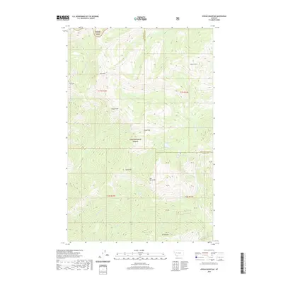
2020 Map of Spread Mountain
USGS Topo · Published 2020About this map
Spread Mountain and East Spread Mountain anchor the central topography of this Montana wilderness, where the boundaries of Lolo National Forest and Flathead National Forest converge. This high-altitude terrain is defined by a series of prominent peaks and drainage systems, with McCabe Mountain to the south and Omar Mountain to the north. A significant geographical corridor is formed at Camp Pass, situated between the headwaters of Falls Creek and the drainage of Lake Creek. The landscape is dotted with remote alpine waters, including Lake Otatsy, Camp Lake, and Canyon Lake, which feed a network of forks and creeks such as West Fork Lake Creek and McCabe Creek. Surveyed section lines and land tracts like PB 42 and PB 43 mark the complex jurisdictional boundaries near the Powell and Lewis and Clark County line.
Find a feature on this map
38 named features on this map. Tap any name to fly to it.
Don’t see what you’re looking for? This feature index may not catch every label — zoom into the map to look around manually.
Map Details
Editions of this 2020 Spread Mountain Map
This is the sole edition of this map. No revisions or reprints were ever made.
Other maps of this area

1902 · Ovando
USGS Topo · 1:125,000

1903 · Coopers Lake
USGS Topo · 1:125,000

1905 · Ovando
USGS Topo · 1:125,000

1955 · Choteau
USGS Topo · 1:250,000

1957 · Choteau
USGS Topo · 1:250,000

1958 · Choteau
USGS Topo · 1:250,000

1962 · Choteau
USGS Topo · 1:250,000

1968 · Spread Mountain
USGS Topo · 1:24,000

1968 · Dunham Point
USGS Topo · 1:24,000
1968 · Coopers Lake
USGS Topo · 1:24,000