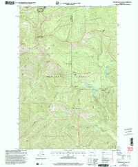
1999 Map of Spread Mountain
USGS Topo · Published 2003About this map
Lolo National Forest and the adjacent Scapegoat Wilderness define this high-altitude landscape along the border of Powell and Lewis and Clark counties. The topography is dominated by massive peaks including Spread Mountain and Omar Mountain, with the Fourth Standard Parallel North bisecting the central terrain.
Find a feature on this map
34 named features on this map. Tap any name to fly to it.
Don’t see what you’re looking for? This feature index may not catch every label — zoom into the map to look around manually.
Map Details
Editions of this 1999 Spread Mountain Map
This is the sole edition of this map. No revisions or reprints were ever made.
Other maps of this area

1902 · Ovando
USGS Topo · 1:125,000

1903 · Coopers Lake
USGS Topo · 1:125,000

1905 · Ovando
USGS Topo · 1:125,000

1955 · Choteau
USGS Topo · 1:250,000

1957 · Choteau
USGS Topo · 1:250,000

1958 · Choteau
USGS Topo · 1:250,000

1962 · Choteau
USGS Topo · 1:250,000

1968 · Spread Mountain
USGS Topo · 1:24,000

1968 · Dunham Point
USGS Topo · 1:24,000
1968 · Coopers Lake
USGS Topo · 1:24,000