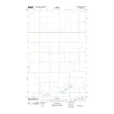
2011 Map of Spring Brook
USGS Topo · Published 2011About this map
Spring Brook anchors this North Dakota landscape, situated along the winding course of Stony Creek just before it feeds into the Epping Dam reservoir. The area is defined by a grid of rural section roads, including County Hwy-8 and County Hwy-11, which connect isolated farmsteads across the high plains of Williams County. A notable cultural landmark, the Upper Missouri Bible Camp, sits near the creek's edge, reflecting the region's community-oriented social geography. The map illustrates a contemporary rural economy where modern infrastructure like 125th Ave NW and 58th St NW overlay traditional water-dependent settlements. This topographic record captures the specific hydrology of the creek system and the structured land divisions typical of the northern prairie, providing a detailed look at the vicinity just east of the Missouri River's influence.
Find a feature on this map
22 named features on this map. Tap any name to fly to it.
Don’t see what you’re looking for? This feature index may not catch every label — zoom into the map to look around manually.
Map Details
Editions of this 2011 Spring Brook Map
This is the sole edition of this map. No revisions or reprints were ever made.
Other maps of this area

1911 · Ray
USGS Topo · 1:125,000

1953 · Williston
USGS Topo · 1:250,000

1957 · Williston
USGS Topo · 1:250,000

1959 · Marmon SE
USGS Topo · 1:24,000

1959 · Williston East
USGS Topo · 1:24,000

1974 · Twin Lakes
USGS Topo · 1:24,000

1978 · Epping NW
USGS Topo · 1:24,000
1978 · Epping NE
USGS Topo · 1:24,000

1978 · Epping
USGS Topo · 1:24,000

1978 · Spring Brook
USGS Topo · 1:24,000