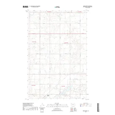
2017 Map of Spring Brook
USGS Topo · Published 2017About this map
Spring Brook anchors the southern portion of this high-plains landscape in Williams County, situated just as the land begins to descend toward the drainage of Stony Cr. The terrain is defined by the headwaters and tributaries of the E Fork Little Muddy River, which meanders through the northern sections. This 2017 survey illustrates a highly organized rural infrastructure, where a rigid grid of gravel roads like 127th Ave NW and 64th St NW segments the prairie into precise sections. In the southeast, the impoundment at Epping Dam creates a localized water feature on Stony Creek, providing a contrast to the surrounding agricultural uplands. The map provides a clear record of contemporary rural North Dakota, showing the relationship between the small settlement of Spring Brook and the surrounding network of farm-to-market roads and water management features.
Find a feature on this map
29 named features on this map. Tap any name to fly to it.
Don’t see what you’re looking for? This feature index may not catch every label — zoom into the map to look around manually.
Map Details
Editions of this 2017 Spring Brook Map
This is the sole edition of this map. No revisions or reprints were ever made.
Other maps of this area

1911 · Ray
USGS Topo · 1:125,000

1953 · Williston
USGS Topo · 1:250,000

1957 · Williston
USGS Topo · 1:250,000

1959 · Marmon SE
USGS Topo · 1:24,000

1959 · Williston East
USGS Topo · 1:24,000

1974 · Twin Lakes
USGS Topo · 1:24,000

1978 · Epping NW
USGS Topo · 1:24,000
1978 · Epping NE
USGS Topo · 1:24,000

1978 · Epping
USGS Topo · 1:24,000

1978 · Spring Brook
USGS Topo · 1:24,000