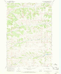
1967 Map of Spring Creek Ranch
USGS Topo · Published 1971About this map
The Crow Indian Reservation Boundary and Northern Cheyenne Indian Reservation Boundary meet in this Big Horn County landscape, where water resources define the remote ranching operations of the late 1960s. The eponymous Spring Creek Ranch is situated among a network of drainages including Cache Creek and Indian Creek. Numerous named water sources such as Fritzler Spring and Commissary Springs appear throughout the broken terrain, alongside topographic features with evocative local names like Moonshine Draw and Schoolhouse Coulee. Evidence of modern utility and remote access is found at the Landing Strip and various Jeep Trails that crisscross the hills. In the southeast, the Upper Indian Creek Reservoir and Lower Indian Creek Reservoir mark significant water management efforts on the reservation lands, providing a detailed look at the infrastructure supporting agriculture and livestock in this high plains region.
Find a feature on this map
18 named features on this map. Tap any name to fly to it.
Don’t see what you’re looking for? This feature index may not catch every label — zoom into the map to look around manually.
Map Details
Editions of this 1967 Spring Creek Ranch Map
2 editions found
Other maps of this area

1894 · Rosebud
USGS Topo · 1:125,000

1901 · Rosebud
USGS Topo · 1:125,000

1954 · Hardin
USGS Topo · 1:250,000

1957 · Hardin
USGS Topo · 1:250,000

1958 · Hardin
USGS Topo · 1:250,000

1958 · Birdseye Spring
USGS Topo · 1:24,000

1967 · Kid Creek
USGS Topo · 1:24,000

1967 · Wolf Mountain Lookout
USGS Topo · 1:24,000

1967 · Kirby
USGS Topo · 1:24,000

1967 · Bar V Ranch NE
USGS Topo · 1:24,000