
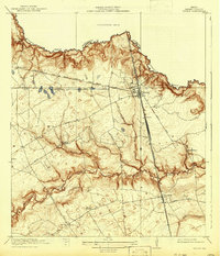
1920 Map of Spring
USGS Topo · Published 1920About this map
The International and Great Northern (Fort Worth Line) and the Galveston Line converge at Spring, forming a vital rail junction north of Houston in the years following the Great War. This survey of northern Harris County captures a landscape transitioning from rural agrarian life to a rail-centered economy, punctuated by community anchors like the Roth School, Kothman School, and Shultz School. The terrain is defined by the winding course of Spring Creek, which marks the boundary with Montgomery County, and the deep drainage patterns of Seals Gully and Cypress Creek. Small settlements like Klein, Bammel, and Westfield serve as local hubs along a network of early motor routes, including Stuebner Road and Kuykendahl Road, which trace the higher ground between the gullies. Family-named landmarks and scattered Cem sites provide specific points of interest for genealogical research in this pre-suburban era.
Find a feature on this map
31 named features on this map. Tap any name to fly to it.
Don’t see what you’re looking for? This feature index may not catch every label — zoom into the map to look around manually.
Map Details
Editions of this 1920 Spring Map
2 editions found
Other maps of this area

1916 · Aldine
USGS Topo · 1:24,000

1916 · Louetta
USGS Topo · 1:24,000

1916 · Satsuma
USGS Topo · 1:24,000

1916 · Humble
USGS Topo · 1:24,000

1916 · Spring
USGS Topo · 1:24,000

1919 · Aldine
USGS Topo · 1:31,680

1919 · Humble
USGS Topo · 1:31,680

1919 · Weeden
USGS Topo · 1:31,680

1920 · Louetta
USGS Topo · 1:31,680
1920 · Satsuma
USGS Topo · 1:31,680