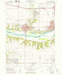
1966 Map of Spring Valley
USGS Topo · Published 1979About this map
The Illinois River serves as a critical geographic divide on this sheet, separating the industrial and residential hubs of Spring Valley and Peru from the agricultural and mining terrain to the south. In the late 1960s, this region was a complex intersection of heavy rail and local industry, with the Chicago Burlington and Quincy and Chicago Rock Island and Pacific railroads threading through the river valley. The landscape is marked by the legacy of resource extraction, specifically seen in the mine dumps near Granville and Mark, and the mine dump just north of Dalzell. Notable local institutions include St. Bede College and Hopkins High School, while numerous cemeteries like St. Valentines Cem and Mt Olivet Cem provide essential data points for genealogical research in this multi-ethnic Illinois coal and river valley corridor.
Find a feature on this map
72 named features on this map. Tap any name to fly to it.
Don’t see what you’re looking for? This feature index may not catch every label — zoom into the map to look around manually.
Map Details
Editions of this 1966 Spring Valley Map
2 editions found
Other maps of this area

1893 · Lacon
USGS Topo · 1:62,500

1893 · Hennepin
USGS Topo · 1:62,500

1893 · Lasalle
USGS Topo · 1:62,500

1909 · Hennepin
USGS Topo · 1:62,500

1911 · La Salle
USGS Topo · 1:62,500

1911 · Hennepin
USGS Topo · 1:62,500

1913 · La Salle
USGS Topo · 1:62,500

1933 · Lacon
USGS Topo · 1:62,500

1934 · Wenona
USGS Topo · 1:48,000

1937 · Lacon
USGS Topo · 1:62,500