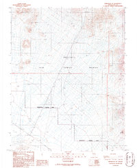
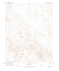
1986 Map of Springdale NE
USGS Topo · Published 1986About this map
Nellis Air Force Range dominates this mid-1980s landscape in southern Nevada, marked by the extensive Restricted Access Area that cordons off vast stretches of high-desert terrain. The geography is characterized by stark features such as Dry Alkali Flat and the prominent height of Little Black Peak. Despite the modern military presence, evidence of earlier industrial and transportation infrastructure remains visible. An Old RR Grade cuts across the southern portion of the quadrangle, tracing the path of former rail operations through the desert. Small-scale resource extraction is also present, indicated by a Gravel Pit and a scattered Prospect, reflecting the long-standing mineral interests typical of the region. The map provides a detailed look at the intersection of federal military control and the residual physical traces of early Nevada development.
Find a feature on this map
8 named features on this map. Tap any name to fly to it.
Don’t see what you’re looking for? This feature index may not catch every label — zoom into the map to look around manually.
Map Details
Editions of this 1986 Springdale NE Map
This is the sole edition of this map. No revisions or reprints were ever made.
Other maps of this area

1908 · Kawich
USGS Topo · 1:250,000

1942 · Tolicha Peak
USGS Topo · 1:125,000
1952 · Black Mtn
USGS Topo · 1:62,500

1954 · Goldfield
USGS Topo · 1:250,000

1955 · Goldfield
USGS Topo · 1:250,000

1958 · Goldfield
USGS Topo · 1:250,000

1962 · Goldfield
USGS Topo · 1:250,000
1966 · Springdale
USGS Topo · 1:62,500
1966 · Thirsty Canyon
USGS Topo · 1:62,500
1968 · Tolicha Peak
USGS Topo · 1:62,500