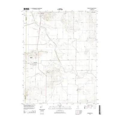
2015 Map of Springerton
USGS Topo · Published 2015About this map
Skillet Fork meanders across the landscape of Mill Shoals and Springerton, defining the lowlands of northwestern White County and eastern Hamilton County. This 2015 survey documents the rural character of the Illinois prairie, where a grid of county roads connects small settlements and isolated farmsteads. Significant local history is preserved through the mapping of numerous family and church burial grounds, including the Kitty Sweeten Cem and Little Zion Cem. The area near Springer Station and Springerton shows the enduring patterns of rural life, with the local economy rooted in the surrounding fields and proximity to water bodies like Broad Run and Beaver Cr. The presence of Railroad St in Mill Shoals points to the historic transportation corridors that once linked these farming communities to the wider region.
Find a feature on this map
27 named features on this map. Tap any name to fly to it.
Don’t see what you’re looking for? This feature index may not catch every label — zoom into the map to look around manually.
Map Details
Editions of this 2015 Springerton Map
This is the sole edition of this map. No revisions or reprints were ever made.
Other maps of this area

1940 · Carmi
USGS Topo · 1:62,500

1941 · Enfield
USGS Topo · 1:62,500

1943 · Carmi
USGS Topo · 1:62,500

1943 · Albion
USGS Topo · 1:62,500

1944 · Enfield
USGS Topo · 1:62,500

1946 · Albion
USGS Topo · 1:62,500

1948 · Fairfield
USGS Topo · 1:62,500

1958 · Belleville
USGS Topo · 1:250,000

1962 · Belleville
USGS Topo · 1:250,000
1971 · Golden Gate
USGS Topo · 1:24,000