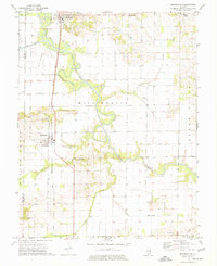
1974 Map of Springerton
USGS Topo · Published 1977About this map
Skillet Fork and its winding Drainage Ditch define the agricultural landscape of this corner of White and Hamilton Counties during the mid-1970s. The village of Springerton stands as a central hub, connected to Mill Shoals to the north by the Baltimore and Ohio railroad corridor. The area is characterized by scattered rural settlements like Jacobs Camp and Anderson, which are interspersed with several small family and community burial grounds including Kitty Sweeten Cem, Hammack Cem, and McIntosh Cem.
Find a feature on this map
28 named features on this map. Tap any name to fly to it.
Don’t see what you’re looking for? This feature index may not catch every label — zoom into the map to look around manually.
Map Details
Editions of this 1974 Springerton Map
This is the sole edition of this map. No revisions or reprints were ever made.
Other maps of this area

1940 · Carmi
USGS Topo · 1:62,500

1941 · Enfield
USGS Topo · 1:62,500

1943 · Carmi
USGS Topo · 1:62,500

1943 · Albion
USGS Topo · 1:62,500

1944 · Enfield
USGS Topo · 1:62,500

1946 · Albion
USGS Topo · 1:62,500

1948 · Fairfield
USGS Topo · 1:62,500

1958 · Belleville
USGS Topo · 1:250,000

1962 · Belleville
USGS Topo · 1:250,000
1971 · Golden Gate
USGS Topo · 1:24,000