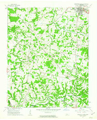
1961 Map of Springfield South
USGS Topo · Published 1963About this map
The southern outskirts of Springfield anchor the rolling landscape of Robertson County in the early 1960s, a region defined by agricultural crossroads and a dense network of local landmarks. The map illustrates a social geography of rural Tennessee, where community life centered on points like Glover Crossroad and Coopertown. Numerous religious and educational sites are documented, including St Michaels Ch, New Chapel Ch, and the Flewellyn School.
Find a feature on this map
55 named features on this map. Tap any name to fly to it.
Don’t see what you’re looking for? This feature index may not catch every label — zoom into the map to look around manually.
Map Details
Editions of this 1961 Springfield South Map
4 editions found
Other maps of this area

1903 · Nashville
USGS Topo · 1:125,000

1931 · Ridgetop
USGS Topo · 1:62,500

1935 · Ridgetop
USGS Topo · 1:62,500

1952 · Springfield North
USGS Topo · 1:24,000

1952 · Youngville
USGS Topo · 1:24,000

1955 · Whites Creek
USGS Topo · 1:24,000

1955 · Forest Grove
USGS Topo · 1:24,000

1956 · Nashville
USGS Topo · 1:250,000

1957 · Adams
USGS Topo · 1:24,000

1957 · Pleasant View
USGS Topo · 1:24,000