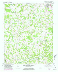
1961 Map of Springfield South
USGS Topo · Published 1980About this map
Springfield sits at the northern edge of this Robertson County landscape, where the town's expansion is visible through 1970s revisions including a golf course and a Radio Tower (WDBL). The southern terrain is defined by the deep dissection of Sycamore Creek and its tributaries like Hollis Creek and Venters Branch. This area preserves a network of small mid-century rural communities such as Coopertown, Flewellyn, and Crunk. Local educational and religious history is well-represented by Bransford High Sch, St Michaels Ch, and the Frierson Chapel. A significant boundary junction is visible at the map's southern border, where Robertson, Cheatham, and Davidson counties meet near Webb Cem. The geography reflects a transition from the agricultural plateaus around Glover Crossroad to the more broken, wooded creek valleys to the south.
Find a feature on this map
59 named features on this map. Tap any name to fly to it.
Don’t see what you’re looking for? This feature index may not catch every label — zoom into the map to look around manually.
Map Details
Editions of this 1961 Springfield South Map
4 editions found
Other maps of this area

1903 · Nashville
USGS Topo · 1:125,000

1931 · Ridgetop
USGS Topo · 1:62,500

1935 · Ridgetop
USGS Topo · 1:62,500

1952 · Springfield North
USGS Topo · 1:24,000

1952 · Youngville
USGS Topo · 1:24,000

1955 · Whites Creek
USGS Topo · 1:24,000

1955 · Forest Grove
USGS Topo · 1:24,000

1956 · Nashville
USGS Topo · 1:250,000

1957 · Adams
USGS Topo · 1:24,000

1957 · Pleasant View
USGS Topo · 1:24,000