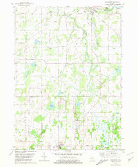
1981 Map of Springport
USGS Topo · Published 1981About this map
Eaton Rapids serves as a primary hub in the northern reach of this landscape, where the Grand River is controlled by the Smithville Dam. The region is defined by a dense network of named highways and a diverse hydrography, including Spring Brook, Willow Creek, and Otter Creek. The industrial and agricultural character of the late 1970s is evident in the Conrail line and several Gravel Pits scattered near the settlement centers.
Find a feature on this map
51 named features on this map. Tap any name to fly to it.
Don’t see what you’re looking for? This feature index may not catch every label — zoom into the map to look around manually.
Map Details
Editions of this 1981 Springport Map
This is the sole edition of this map. No revisions or reprints were ever made.
Other maps of this area

1910 · Lansing
USGS Topo · 1:62,500

1912 · Lansing
USGS Topo · 1:62,500

1919 · Springport
USGS Topo · 1:62,500

1921 · Springport
USGS Topo · 1:62,500

1921 · Marshall
USGS Topo · 1:62,500

1923 · Marshall
USGS Topo · 1:62,500

1943 · Marshall
USGS Topo · 1:62,500

1949 · Charlotte
USGS Topo · 1:62,500

1958 · Grand Rapids
USGS Topo · 1:250,000

1961 · Grand Rapids
USGS Topo · 1:250,000