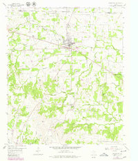
1958 Map of Springtown
USGS Topo · Published 1979About this map
Springtown Oil Field dominates the northern landscape of this Parker County region, illustrating the post-war energy development that shaped North Texas. The settlement of Springtown serves as the central hub, where the High Sch and residential blocks meet a network of rural roads. To the south, the landscape becomes more varied, defined by the winding paths of Walnut Creek and Woody Creek.
Find a feature on this map
33 named features on this map. Tap any name to fly to it.
Don’t see what you’re looking for? This feature index may not catch every label — zoom into the map to look around manually.
Map Details
Editions of this 1958 Springtown Map
4 editions found

Other maps of this area

1891 · Weatherford
USGS Topo · 1:125,000

1893 · Weatherford
USGS Topo · 1:125,000

1924 · Sunset 4-d
USGS Topo · 1:48,000

1930 · Boyd
USGS Topo · 1:62,500

1932 · Springtown
USGS Topo · 1:62,500

1954 · Dallas
USGS Topo · 1:250,000

1954 · Sherman
USGS Topo · 1:250,000

1955 · Azle
USGS Topo · 1:24,000
1955 · Springtown SE
USGS Topo · 1:24,000

1958 · Dallas
USGS Topo · 1:250,000