1954 Map of St Catherines Sound
USGS Topo · Published 1958About this map
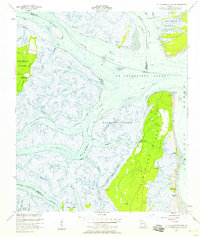
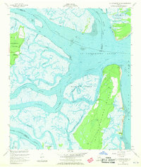
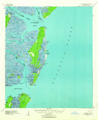
St Catherines Island and Ossabaw Island dominate this coastal Georgia landscape, separated by the wide waters of St Catherines Sound. During the mid-1950s, this intricate network of salt marshes and tidal rivers served as a critical passage for marine traffic along the Intracostal Waterway. The mainland features the small settlement at Yellow Bluff, where the Yellow Bluff Fishing Camp and the nearby Youmans Landing Field suggest a mid-century period of local recreation and light aviation. Navigational markers and several Artesian Wells are scattered across the islands, indicating the necessary infrastructure for maintaining life and transit in this hydrologically complex environment. The map details the convergence of the Medway River and North Newport River, tracing the shifting sands of the Medway Spit and the deep channels of McQueen Inlet as they meet the Atlantic Ocean.
Find a feature on this map
47 named features on this map. Tap any name to fly to it.
Don’t see what you’re looking for? This feature index may not catch every label — zoom into the map to look around manually.
Map Details
Editions of this 1954 St Catherines Sound Map
2 editions found
Other maps of this area

1920 · Sapelo River
USGS Topo · 1:62,500

1920 · Limerick
USGS Topo · 1:62,500

1928 · St Catherines Island
USGS Topo · 1:62,500
1943 · St Catherines Island
USGS Topo · 1:62,500

1943 · Sapelo River
USGS Topo · 1:62,500

1944 · Limerick
USGS Topo · 1:62,500

1944 · Ossabaw Island
USGS Topo · 1:62,500
1945 · St. Catherine's Island
USGS Topo · 1:62,500

1945 · Ossabaw Island
USGS Topo · 1:62,500

1945 · Sapelo River
USGS Topo · 1:62,500