
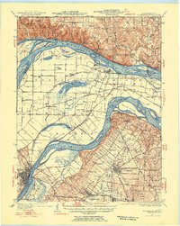
1927 Map of St. Charles
USGS Topo · Published 1955About this map
The confluence of the Mississippi River and Missouri River dominates this mid-century landscape, revealing a complex network of islands, sloughs, and low-lying farmstead plains. The river-driven geography includes significant features like Pelican Island and Portage Island, while the fertile land between the channels is dotted with rural institutions such as Cul de Sac Sch and Point Prairie Sch. In the south, the early aviation footprint of Lambert Airport and Smart Airfield marks the growing infrastructure of the St. Louis metropolitan fringe.
Find a feature on this map
90 named features on this map. Tap any name to fly to it.
Don’t see what you’re looking for? This feature index may not catch every label — zoom into the map to look around manually.
Map Details
Editions of this 1927 St. Charles Map
2 editions found
Other maps of this area

1888 · St. Louis
USGS Topo · 1:62,500

1903 · O'Fallon
USGS Topo · 1:125,000

1924 · Robertson
USGS Topo · 1:24,000

1925 · Brighton
USGS Topo · 1:62,500

1927 · Alton
USGS Topo · 1:62,500

1928 · Brighton
USGS Topo · 1:62,500

1930 · Hardin
USGS Topo · 1:62,500

1930 · Jerseyville
USGS Topo · 1:62,500

1931 · Brussels
USGS Topo · 1:62,500

1932 · Manchester NE
USGS Topo · 1:24,000