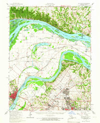
1954 Map of St. Charles
USGS Topo · Published 1966About this map
The confluence of the Mississippi River and Missouri River dominates this mid-century landscape, framing a region defined by its complex riverine geography and growing aviation infrastructure. Aviation is a major presence, anchored by the Lambert-St Louis Airport in the south, complemented by smaller fields like Kratz Airport and Smartt Airfield. The river valleys are crisscrossed by historical ferry crossings including Halls Ferry and Commerce Ferry, while the lowlands between the rivers feature intricate wetland systems like Marais Temps Clair and Marais Croche.
Find a feature on this map
110 named features on this map. Tap any name to fly to it.
Don’t see what you’re looking for? This feature index may not catch every label — zoom into the map to look around manually.
Map Details
Editions of this 1954 St. Charles Map
2 editions found
Other maps of this area

1888 · St. Louis
USGS Topo · 1:62,500

1903 · O'Fallon
USGS Topo · 1:125,000

1924 · Robertson
USGS Topo · 1:24,000

1925 · Brighton
USGS Topo · 1:62,500

1927 · Alton
USGS Topo · 1:62,500

1927 · St. Charles
USGS Topo · 1:62,500

1928 · Brighton
USGS Topo · 1:62,500

1930 · Hardin
USGS Topo · 1:62,500

1930 · Jerseyville
USGS Topo · 1:62,500

1931 · Brussels
USGS Topo · 1:62,500