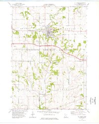
1974 Map of St Charles
USGS Topo · Published 1976About this map
The city of St Charles serves as the focal point of this mid-1970s topographic study, situated where the Chicago and North Western rail line traverses the landscape near the Fairground. The terrain is defined by the winding course of the South Fork Whitewater River and Trout Run, which carve through the Minnesota Memorial Hardwood State Forest. This period shows a community balanced between its industrial infrastructure, including a local Water Tank and Sewage Disposal plant, and its recreational spaces like Sportsman Park.
Find a feature on this map
26 named features on this map. Tap any name to fly to it.
Don’t see what you’re looking for? This feature index may not catch every label — zoom into the map to look around manually.
Map Details
Editions of this 1974 St Charles Map
This is the sole edition of this map. No revisions or reprints were ever made.
Other maps of this area

1932 · Cochrane
USGS Topo · 1:62,500

1934 · Plainview
USGS Topo · 1:62,500

1934 · Cochrane
USGS Topo · 1:62,500

1937 · Cochrane
USGS Topo · 1:62,500

1938 · Plainview
USGS Topo · 1:62,500

1953 · Saint Paul
USGS Topo · 1:250,000

1953 · Eau Claire
USGS Topo · 1:250,000

1954 · Chatfield
USGS Topo · 1:62,500

1954 · Lewiston
USGS Topo · 1:62,500

1954 · Mason City
USGS Topo · 1:250,000