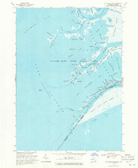
1968 Map of St. Clair Flats
USGS Topo · Published 1971About this map
St Clair Flats State Wildlife Area dominates this intricate 1968 aquatic landscape where the St Clair River meets Lake St Clair. The map reveals a complex network of channels and marshlands, notably the Middle Channel and South Bend, which define the fragmented terrain of Harsens Island and Dickinson Island. The border between Michigan and Ontario bisects the waterways, placing the Walpole Island Indian Reserve on the Canadian side adjacent to American settlements like Riverside and Miller.
Find a feature on this map
91 named features on this map. Tap any name to fly to it.
Don’t see what you’re looking for? This feature index may not catch every label — zoom into the map to look around manually.
Map Details
Editions of this 1968 St. Clair Flats Map
2 editions found
Other maps of this area

1905 · Grosse Pointe
USGS Topo · 1:62,500

1912 · Mt Clemens
USGS Topo · 1:62,500

1914 · Algonac
USGS Topo · 1:62,500

1918 · Grosse Pointe
USGS Topo · 1:62,500

1929 · Mt Clemens
USGS Topo · 1:62,500

1936 · New Haven
USGS Topo · 1:31,680

1936 · Selfridge Field
USGS Topo · 1:31,680

1936 · New Baltimore
USGS Topo · 1:31,680

1936 · Algonac
USGS Topo · 1:31,680

1939 · New Baltimore
USGS Topo · 1:24,000