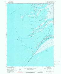
1968 Map of St. Clair Flats
USGS Topo · Published 1989About this map
St Clair Flats State Wildlife Area dominates this intricate delta landscape where the river meets Lake St Clair. The map reveals a complex network of wetlands and aquatic thoroughfares, including Chenal A Bout, Middle Channel, and numerous "highways" like Johnnies Hy and Moross Hy that carve through the marshes. Small settlements such as Club Island, Riverside, and Miller are positioned along these waterways, reflecting a community deeply integrated with the seasonal rhythms of the delta. Across the international boundary, the Walpole Island Indian Reserve spans the eastern portion of the sheet.
Find a feature on this map
83 named features on this map. Tap any name to fly to it.
Don’t see what you’re looking for? This feature index may not catch every label — zoom into the map to look around manually.
Map Details
Editions of this 1968 St. Clair Flats Map
2 editions found
Other maps of this area

1905 · Grosse Pointe
USGS Topo · 1:62,500

1912 · Mt Clemens
USGS Topo · 1:62,500

1914 · Algonac
USGS Topo · 1:62,500

1918 · Grosse Pointe
USGS Topo · 1:62,500

1929 · Mt Clemens
USGS Topo · 1:62,500

1936 · New Haven
USGS Topo · 1:31,680

1936 · Selfridge Field
USGS Topo · 1:31,680

1936 · New Baltimore
USGS Topo · 1:31,680

1936 · Algonac
USGS Topo · 1:31,680

1939 · New Baltimore
USGS Topo · 1:24,000