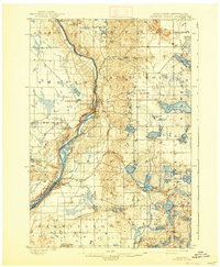
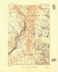
1901 Map of St Croix Dalles
USGS Topo · Published 1938About this map
The ST. Croix River carves a deep valley through this glacial landscape, serving as the border between Wisconsin and Minnesota at the turn of the century. The twin settlements of St. Croix Falls and Taylors Falls anchor the central dalles, where the river narrows between trap rock cliffs. This 1897 survey records a period of significant rail expansion, showing the ST. Paul and Duluth R. R. and the Minneapolis St. Paul and Sault Ste. Marie Ry branching through the region. To the east and west, the terrain is defined by a dense network of kettle lakes, including Deer Lake, Big Horseshoe Lake, and Osceola Lake. Small agricultural hubs and junctions such as Osceola, Dresser Junction, and Franconia Station are positioned along these rail corridors, illustrating the late-nineteenth-century reliance on steam transport to connect rural Polk and Chisago counties to larger markets.
Find a feature on this map
65 named features on this map. Tap any name to fly to it.
Don’t see what you’re looking for? This feature index may not catch every label — zoom into the map to look around manually.
Map Details
Editions of this 1901 St Croix Dalles Map
6 editions found
Other maps of this area

1900 · St Croix Dalles
USGS Topo · 1:62,500

1901 · St Croix Dalles
USGS Topo · 1:62,500

1948 · New Richmond
USGS Topo · 1:62,500

1948 · Stillwater
USGS Topo · 1:62,500

1949 · New Richmond
USGS Topo · 1:62,500

1949 · Stillwater
USGS Topo · 1:62,500

1950 · Rush City
USGS Topo · 1:48,000

1950 · Deer Park
USGS Topo · 1:62,500

1950 · Balsam Lake
USGS Topo · 1:62,500

1951 · Milltown
USGS Topo · 1:48,000