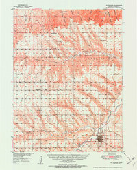
1951 Map of St. Francis
USGS Topo · Published 1951About this map
St Francis serves as the hub of this Northwest Kansas landscape, situated where the Chicago Burlington and Quincy rail line meets the South Fork Republican River. The area is characterized by a dense network of early rural social structures, including nearly a dozen scattered schools such as German Plains Sch and Prairie Belle Sch, reflecting a highly localized agrarian community. Along the river valley near the town center, a Municipal Airport and City Lake highlight the mid-century development of local infrastructure.
Find a feature on this map
50 named features on this map. Tap any name to fly to it.
Don’t see what you’re looking for? This feature index may not catch every label — zoom into the map to look around manually.
Map Details
Editions of this 1951 St. Francis Map
3 editions found
Other maps of this area

1942 · St. Francis
USGS Topo · 1:62,500

1943 · St. Francis
USGS Topo · 1:62,500

1950 · Bonny Reservoir
USGS Topo · 1:62,500

1951 · St Francis
USGS Topo · 1:62,500

1951 · Bird City North
USGS Topo · 1:62,500

1951 · Bird City South
USGS Topo · 1:62,500

1952 · St Francis 3
USGS Topo · 1:62,500

1954 · Limon
USGS Topo · 1:250,000

1954 · Sterling
USGS Topo · 1:250,000

1954 · McCook
USGS Topo · 1:250,000