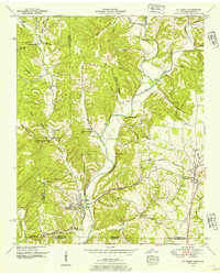
1950 Map of St. Joseph
USGS Topo · Published 1954About this map
Iron City and St Joseph anchor this mid-century survey of the rugged borderland where the Tennessee and Alabama state lines meet. The landscape is defined by the winding course of Shoal Creek and its many tributaries, including Holly Creek, Wolf Creek, and Butler Creek. The Louisville and Nashville Railroad and the Jackson Highway provide the primary north-south transit corridors through this transition from agricultural valley floor to the dissected uplands of the Highland Rim.
Find a feature on this map
44 named features on this map. Tap any name to fly to it.
Don’t see what you’re looking for? This feature index may not catch every label — zoom into the map to look around manually.
Map Details
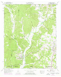
Editions of this 1950 St. Joseph Map
2 editions found
Other maps of this area

1905 · Waynesboro
USGS Topo · 1:125,000

1914 · Rogersville
USGS Topo · 1:48,000

1914 · Muscle Shoals
USGS Topo · 1:48,000

1916 · Muscle Shoals
USGS Topo · 1:62,500

1916 · Rogersville
USGS Topo · 1:62,500

1936 · Westpoint
USGS Topo · 1:24,000

1936 · Collinwood
USGS Topo · 1:24,000

1936 · Light
USGS Topo · 1:24,000

1936 · Long Branch
USGS Topo · 1:24,000

1936 · Loretto
USGS Topo · 1:24,000