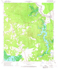
1967 Map of St. Landry
USGS Topo · Published 1968About this map
Chicot State Park dominates the eastern half of this landscape, its intricate shoreline framing Chicot Lake and Negro Lake. The map reveals a rural economy organized around family landmarks and small communities like Bayou Chicot and Dossman. Genealogists will find a high density of rural cemeteries, including Chaney Cem, Keller Cem, Clark Cem, and Ferguson Cem, which are scattered throughout the wooded and agricultural plots. The Texas and Pacific railroad line runs along the eastern border through the settlement of St Landry, illustrating the transportation corridor that serviced this portion of the St Landry and Evangeline Parish border. Significant water features like Mountain Bayou Lake and Millers Lake punctuate the terrain, showing the drainage patterns through various bayous and sloughs.
Find a feature on this map
34 named features on this map. Tap any name to fly to it.
Don’t see what you’re looking for? This feature index may not catch every label — zoom into the map to look around manually.
Map Details
Editions of this 1967 St. Landry Map
2 editions found
Other maps of this area

1935 · Turkey Creek
USGS Topo · 1:62,500

1939 · Opelousas
USGS Topo · 1:62,500

1947 · Ville Platte
USGS Topo · 1:31,680

1948 · Bunkie
USGS Topo · 1:62,500

1949 · Turkey Creek
USGS Topo · 1:62,500

1952 · Lake Charles
USGS Topo · 1:250,000

1954 · Lake Charles
USGS Topo · 1:250,000

1956 · Opelousas
USGS Topo · 1:62,500

1957 · Opelousas
USGS Topo · 1:62,500
1960 · Ville Platte
USGS Topo · 1:62,500