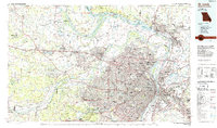
1985 Map of St Louis
USGS Topo · Published 1985About this map
The confluence of the Mississippi River, Missouri River, and Illinois River anchors this mid-1980s look at the bi-state metropolitan region. The heavy concentration of rail lines, including the Terminal Railroad Association and Norfolk and Western, highlights the area's enduring role as a primary Midwestern transportation hub. Urban density radiates from the riverfront through St Louis into mature suburbs like University City, Clayton, and Webster Groves, while the Illinois side shows the industrial footprint of East St Louis and Granite City.
Find a feature on this map
289 named features on this map. Tap any name to fly to it.
Don’t see what you’re looking for? This feature index may not catch every label — zoom into the map to look around manually.
Map Details
Editions of this 1985 St Louis Map
3 editions found
Other maps of this area

1888 · St. Louis
USGS Topo · 1:62,500

1890 · Louisiana
USGS Topo · 1:125,000

1890 · Hermann
USGS Topo · 1:125,000

1901 · De Soto
USGS Topo · 1:125,000

1903 · O'Fallon
USGS Topo · 1:125,000

1903 · Sullivan
USGS Topo · 1:125,000

1907 · Belleville
USGS Topo · 1:62,500

1910 · Waterloo
USGS Topo · 1:62,500

1912 · New Athens
USGS Topo · 1:62,500

1912 · Kimmswick
USGS Topo · 1:62,500