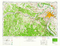
1962 Map of St. Louis
USGS Topo · Published 1962About this map
The confluence of the Mississippi River and the Missouri River anchors this regional overview of the mid-century Midwest, centered on the urban core of St Louis. This 1962 edition illustrates the post-war expansion of the metropolitan area, showing the established river towns of Alton and St Charles alongside the growing suburbs of Florissant, Kirkwood, and Overland. To the west, the landscape shifts into the Ozark foothills, where the Meramec River and Bourbeuse River wind through heavily forested areas including portions of the Clark National Forest.
Find a feature on this map
68 named features on this map. Tap any name to fly to it.
Don’t see what you’re looking for? This feature index may not catch every label — zoom into the map to look around manually.
Map Details
Editions of this 1962 St. Louis Map
This is the sole edition of this map. No revisions or reprints were ever made.
Other maps of this area

1886 · Jefferson City
USGS Topo · 1:125,000

1888 · Tuscumbia
USGS Topo · 1:125,000

1888 · St. Louis
USGS Topo · 1:62,500

1890 · Louisiana
USGS Topo · 1:125,000
1890 · Mexico
USGS Topo · 1:125,000

1890 · Moberly
USGS Topo · 1:125,000

1890 · Hermann
USGS Topo · 1:125,000

1890 · Fulton
USGS Topo · 1:125,000

1894 · Tuscumbia
USGS Topo · 1:125,000
1894 · Jefferson City
USGS Topo · 1:125,000