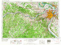
1966 Map of St. Louis
USGS Topo · Published 1966About this map
St. Louis and the industrial hub of East St. Louis anchor this mid-1960s landscape, where the confluence of the Missouri River and Mississippi River dictates the region's geography. The map illustrates a period of significant urban expansion, with residential growth stretching toward Florissant and St. Charles. This suburban sprawl is punctuated by major infrastructure, including the Lambert-St. Louis Municipal Airport and the sprawling Weldon Spring Ordnance Plant.
Find a feature on this map
89 named features on this map. Tap any name to fly to it.
Don’t see what you’re looking for? This feature index may not catch every label — zoom into the map to look around manually.
Map Details
Editions of this 1966 St. Louis Map
This is the sole edition of this map. No revisions or reprints were ever made.
Other maps of this area

1886 · Jefferson City
USGS Topo · 1:125,000

1888 · Tuscumbia
USGS Topo · 1:125,000

1888 · St. Louis
USGS Topo · 1:62,500

1890 · Louisiana
USGS Topo · 1:125,000
1890 · Mexico
USGS Topo · 1:125,000

1890 · Moberly
USGS Topo · 1:125,000

1890 · Hermann
USGS Topo · 1:125,000

1890 · Fulton
USGS Topo · 1:125,000

1894 · Tuscumbia
USGS Topo · 1:125,000
1894 · Jefferson City
USGS Topo · 1:125,000