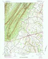
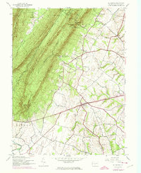
1944 Map of St Thomas
USGS Topo · Published 1984About this map
St Thomas serves as a central hub in this Franklin County landscape, where the agricultural lowlands meet the formidable ridges of the Appalachian Mountains. The terrain is defined by the massive parallel heights of Kittatinny Mountain and Broad Mountain, separated by the secluded Horse Valley. These ridges are punctuated by several natural crossings, including Hendrix Gap and Yankees Gap, which historically dictated travel and drainage patterns toward the W Br Conococheague Creek in the south.
Find a feature on this map
29 named features on this map. Tap any name to fly to it.
Don’t see what you’re looking for? This feature index may not catch every label — zoom into the map to look around manually.
Map Details
Editions of this 1944 St Thomas Map
5 editions found
Other maps of this area

1900 · Mercersburg
USGS Topo · 1:62,500

1902 · Chambersburg
USGS Topo · 1:62,500

1902 · Mercersburg
USGS Topo · 1:62,500

1923 · Shippensburg
USGS Topo · 1:62,500

1939 · Orbisonia
USGS Topo · 1:62,500

1940 · Orbisonia
USGS Topo · 1:62,500

1942 · Hagerstown
USGS Topo · 1:125,000

1943 · Hagerstown
USGS Topo · 1:125,000

1943 · Mercersburg
USGS Topo · 1:24,000

1943 · Chambersburg
USGS Topo · 1:62,500
Featured Places
- Metal Township, PA
- Hamilton Township, PA
- Letterkenny Township, PA
- Edenville, St. Thomas Township
- Peters Township, PA