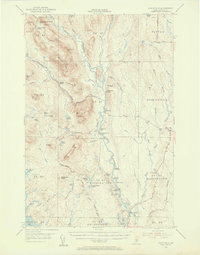
1953 Map of Stacyville
USGS Topo · Published 1956About this map
The East Branch Penobscot River winds through this mid-century survey of Penobscot County, a landscape defined by the Maine woods' industrial and recreational history. In the east, the settlement of Stacyville sits alongside the Bangor and Aroostook railroad, serving as a gateway to the more remote townships like Soldiertown and Grindstone. The map traces an era of backcountry management and forestry, evidenced by the Deasey Fire Tower atop Deasey Mtn and the Forest Service Camp near Whetstone Falls. Notable family and commercial landmarks such as Hunt Farm and Lunksoos Camp indicate long-standing hubs for logging and sporting. Significant water features like the Wassataquoik Stream and Seboeis River provided the necessary drainage and transport routes for the region's timber heritage, while the Sandbank Trail offers a glimpse into the historic pathwork of the North Woods.
Find a feature on this map
79 named features on this map. Tap any name to fly to it.
Don’t see what you’re looking for? This feature index may not catch every label — zoom into the map to look around manually.
Map Details
Editions of this 1953 Stacyville Map
4 editions found

Other maps of this area

1927 · Katahdin
USGS Topo · 1:48,000

1930 · Katahdin
USGS Topo · 1:62,500

1940 · Island Falls
USGS Topo · 1:62,500

1940 · Sherman
USGS Topo · 1:62,500

1940 · Mattawamkeag
USGS Topo · 1:62,500

1942 · Island Falls
USGS Topo · 1:62,500

1942 · Mattawamkeag
USGS Topo · 1:62,500

1942 · Sherman
USGS Topo · 1:62,500

1949 · Katahdin
USGS Topo · 1:62,500

1951 · Norcross
USGS Topo · 1:62,500