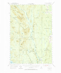
1953 Map of Stacyville
USGS Topo · Published 1969About this map
The East Branch Penobscot River carves a central path through this wilderness during the early 1950s, defining a landscape of timber tracts and isolated outposts. The map documents the northern Maine woods when remote locations like Hunt Farm and Lunksoos Camp served as critical points for forestry and river operations. To the east, the Bangor and Aroostook railroad corridor provides the primary industrial link for the town of Stacyville and nearby Happy Corner.
Find a feature on this map
120 named features on this map. Tap any name to fly to it.
Don’t see what you’re looking for? This feature index may not catch every label — zoom into the map to look around manually.
Map Details
Editions of this 1953 Stacyville Map
4 editions found

Other maps of this area

1927 · Katahdin
USGS Topo · 1:48,000

1930 · Katahdin
USGS Topo · 1:62,500

1940 · Island Falls
USGS Topo · 1:62,500

1940 · Sherman
USGS Topo · 1:62,500

1940 · Mattawamkeag
USGS Topo · 1:62,500

1942 · Island Falls
USGS Topo · 1:62,500

1942 · Mattawamkeag
USGS Topo · 1:62,500

1942 · Sherman
USGS Topo · 1:62,500

1949 · Katahdin
USGS Topo · 1:62,500

1951 · Norcross
USGS Topo · 1:62,500