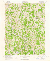
1961 Map of Stafford
USGS Topo · Published 1963About this map
Stafford and Harriettsville anchor this early 1960s survey of the southeastern Ohio hill country, where the landscape is defined by the winding drainages of East Fork Duck Creek and the Little Muskingum River. The area shows a clear pattern of ridge-top and valley-floor habitation, with family and community life centered around landmarks like Mt Tabor Ch, Sutherland Ch, and the Township Sch. Large portions of the terrain fall within the Wayne National Forest, emphasizing the transition from early resource extraction to protected forest land. Evidence of the region's industrial footprint is visible through scattered Strip Mine operations and several Gas Wells, highlighting the persistent reliance on coal and natural gas. For genealogists, the map preserves the exact locations of several small burial sites, including Stewart Cem and Zion Cem, providing a precise record of rural community centers in Monroe County and Noble County.
Find a feature on this map
41 named features on this map. Tap any name to fly to it.
Don’t see what you’re looking for? This feature index may not catch every label — zoom into the map to look around manually.
Map Details
Editions of this 1961 Stafford Map
3 editions found
Other maps of this area

1903 · Macksburg
USGS Topo · 1:62,500

1905 · New Matamoras
USGS Topo · 1:62,500

1905 · Woodsfield
USGS Topo · 1:62,500

1905 · Macksburg
USGS Topo · 1:62,500

1909 · Summerfield
USGS Topo · 1:62,500

1911 · Summerfield
USGS Topo · 1:62,500

1924 · New Matamoras
USGS Topo · 1:62,500

1926 · New Matamoras
USGS Topo · 1:62,500

1949 · Clarksburg
USGS Topo · 1:250,000

1956 · Clarksburg
USGS Topo · 1:250,000