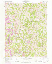
1961 Map of Stafford
USGS Topo · Published 1977About this map
Wayne National Forest encompasses much of this landscape in southeast Ohio, where the drainage of Duck Creek and its many forks carves through the terrain. The settlement of Stafford serves as a local hub, surrounded by smaller communities such as Carlisle, Harriettsville, and Road Fork. This 1961 record, with purple updates from 1976, illustrates an economy transitioning from traditional farming to extraction, evidenced by various Strip Mines and oil wells scattered across the ridges. Genealogists will find several rural landmarks of interest, including the Township Sch and numerous country churches like Crum Ridge Ch and Mt Tabor Ch. The map also captures the historical boundaries of the Congress Lands Old Seven Ranges, a significant marker of early American land division that continues to shape the geopolitical lines between Noble Co and Monroe Co.
Find a feature on this map
43 named features on this map. Tap any name to fly to it.
Don’t see what you’re looking for? This feature index may not catch every label — zoom into the map to look around manually.
Map Details
Editions of this 1961 Stafford Map
3 editions found
Other maps of this area

1903 · Macksburg
USGS Topo · 1:62,500

1905 · New Matamoras
USGS Topo · 1:62,500

1905 · Woodsfield
USGS Topo · 1:62,500

1905 · Macksburg
USGS Topo · 1:62,500

1909 · Summerfield
USGS Topo · 1:62,500

1911 · Summerfield
USGS Topo · 1:62,500

1924 · New Matamoras
USGS Topo · 1:62,500

1926 · New Matamoras
USGS Topo · 1:62,500

1949 · Clarksburg
USGS Topo · 1:250,000

1956 · Clarksburg
USGS Topo · 1:250,000