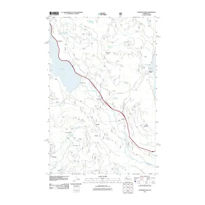
2011 Map of Stampede Pass
USGS Topo · Published 2011About this map
Keechelus Lake and the engineering of the Keechelus Dam dominate this mountain landscape, which serves as a critical corridor for transportation across the Cascades. The map highlights the deep-rooted infrastructure of the region, specifically the Stampede Tunnel and the historical rail alignment now designated as the Iron Horse Trl. Small settlements and seasonal hubs like Whittier, Martin, and Stampede are shown alongside recreation points such as the Kachess Resort and Crystal Springs Campground. The terrain is characterized by steep ridges and narrow drainage basins, with the Yakima River flowing southeast from the dam. The presence of the Lake Keechelus Snowshed Tunnel underscores the challenges of maintaining transit routes through this high-altitude pass during the winter months.
Find a feature on this map
38 named features on this map. Tap any name to fly to it.
Don’t see what you’re looking for? This feature index may not catch every label — zoom into the map to look around manually.
Map Details
Editions of this 2011 Stampede Pass Map
This is the sole edition of this map. No revisions or reprints were ever made.
Other maps of this area

1901 · Snoqualmie Pass
USGS Topo · 1:125,000

1903 · Snoqualmie
USGS Topo · 1:125,000

1957 · Wenatchee
USGS Topo · 1:250,000

1961 · Snoqualmie Pass
USGS Topo · 1:62,500

1961 · Easton
USGS Topo · 1:62,500

1961 · Kachess Lake
USGS Topo · 1:62,500

1962 · Lester
USGS Topo · 1:62,500

1975 · Snoqualmie Pass
USGS Topo · 1:100,000

1989 · Easton
USGS Topo · 1:24,000
1989 · Stampede Pass
USGS Topo · 1:24,000