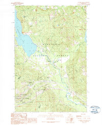
1989 Map of Stampede Pass
USGS Topo · Published 1989About this map
The high Cascades divide at Stampede Pass defines this 1989 topographic study, where the transportation engineering of the late 20th century meets the protected wilderness of the Wenatchee National Forest. This section of the range is a critical corridor for both water and rail, dominated by the massive Keechelus Lake and the infrastructure required to move freight through the mountains. The presence of the Stampede Tunnel and the Whittier (Site) highlights the historical significance of this rail route, which carved through the ridge long before modern interstate developments.
Find a feature on this map
47 named features on this map. Tap any name to fly to it.
Don’t see what you’re looking for? This feature index may not catch every label — zoom into the map to look around manually.
Map Details
Editions of this 1989 Stampede Pass Map
2 editions found
Other maps of this area

1901 · Snoqualmie Pass
USGS Topo · 1:125,000

1903 · Snoqualmie
USGS Topo · 1:125,000

1957 · Wenatchee
USGS Topo · 1:250,000

1961 · Snoqualmie Pass
USGS Topo · 1:62,500

1961 · Easton
USGS Topo · 1:62,500

1961 · Kachess Lake
USGS Topo · 1:62,500

1962 · Lester
USGS Topo · 1:62,500

1975 · Snoqualmie Pass
USGS Topo · 1:100,000

1989 · Easton
USGS Topo · 1:24,000
1989 · Lester
USGS Topo · 1:24,000