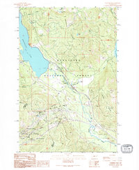
1989 Map of Stampede Pass
USGS Topo · Published 1995About this map
Keechelus Ridge dominates the skyline between the deep waters of Keechelus Lake and the upper reaches of the Yakima River during the late 1980s. This survey documents the critical transportation corridor of the Cascade Range, defined by the engineering feat of the Pacific Stampede Tunnel passing beneath the crest. Local settlement is sparse, marked by the small communities of Martin and Stampede, as well as the former location of Whittier.
Find a feature on this map
57 named features on this map. Tap any name to fly to it.
Don’t see what you’re looking for? This feature index may not catch every label — zoom into the map to look around manually.
Map Details
Editions of this 1989 Stampede Pass Map
2 editions found
Other maps of this area

1901 · Snoqualmie Pass
USGS Topo · 1:125,000

1903 · Snoqualmie
USGS Topo · 1:125,000

1957 · Wenatchee
USGS Topo · 1:250,000

1961 · Snoqualmie Pass
USGS Topo · 1:62,500

1961 · Easton
USGS Topo · 1:62,500

1961 · Kachess Lake
USGS Topo · 1:62,500

1962 · Lester
USGS Topo · 1:62,500

1975 · Snoqualmie Pass
USGS Topo · 1:100,000

1989 · Easton
USGS Topo · 1:24,000
1989 · Stampede Pass
USGS Topo · 1:24,000