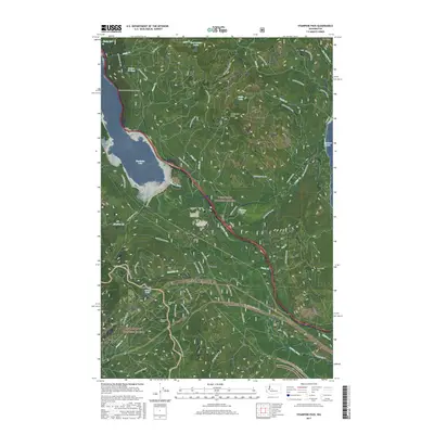
2017 Map of Stampede Pass
USGS Topo · Published 2017About this map
Stampede Pass serves as a critical corridor through the Cascades, where modern forest management and historical rail infrastructure converge. This 2017 survey details the mountain crossing between the Wenatchee National Forest and Snoqualmie National Forest, featuring the significant Stampede Tunnel and the Lake Keechelus Snowshed Tunnel along the western edge of Keechelus Lake. The map captures the industrial and recreational utility of the land, tracing the Pacific Crest National Scenic Trail as it winds near the high points of Keechelus Ridge and Amabilis Mtn. The landscape is dotted with small named nodes such as Whittier, Martin, and Stampede, which follow the primary rail and water routes. The headwaters of the Yakima River flow south from the lake, while an intricate network of National Forest Development Roads provides access to remote water bodies like Swamp Lake, Baker Lake, and Lizard Lake.
Find a feature on this map
70 named features on this map. Tap any name to fly to it.
Don’t see what you’re looking for? This feature index may not catch every label — zoom into the map to look around manually.
Map Details
Editions of this 2017 Stampede Pass Map
This is the sole edition of this map. No revisions or reprints were ever made.
Other maps of this area

1901 · Snoqualmie Pass
USGS Topo · 1:125,000

1903 · Snoqualmie
USGS Topo · 1:125,000

1957 · Wenatchee
USGS Topo · 1:250,000

1961 · Snoqualmie Pass
USGS Topo · 1:62,500

1961 · Easton
USGS Topo · 1:62,500

1961 · Kachess Lake
USGS Topo · 1:62,500

1962 · Lester
USGS Topo · 1:62,500

1975 · Snoqualmie Pass
USGS Topo · 1:100,000

1989 · Easton
USGS Topo · 1:24,000
1989 · Stampede Pass
USGS Topo · 1:24,000